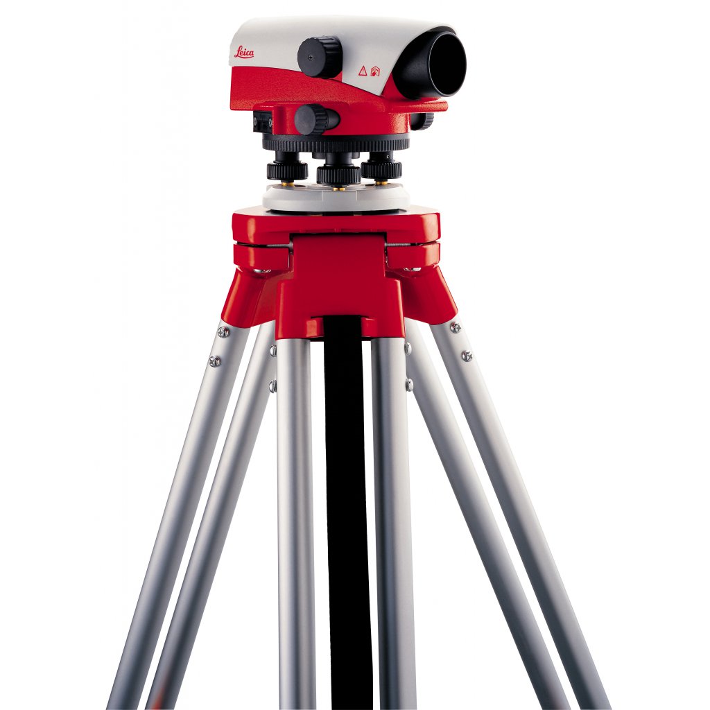


An automatic level instrument is a surveying tool used to measure the difference in elevation between two points. Unlike traditional levels that require manual leveling, automatic levels incorporate a compensator that automatically adjusts for slight tilts, making the leveling process significantly faster and easier. This technology has revolutionized surveying practices, making it accessible to a wider range of professionals.
Professionals who commonly use automatic level instruments include:
-
Surveyors:
-
Topographic Surveys: This type of surveying is carried out to determine the undulating nature of the earth surface, depicting the location, size, height and any change in elevation. The data from the level is used to create detailed maps of land surfaces, including elevations, contours, and features.
-
Control Surveys: Provides reference points as a foundation for every other survey to be carried out in a certain geographical area. This survey Establishes precise horizontal and vertical control points for other surveying activities.
-
Construction Surveys: This type of survey guides the construction of new structures such as roads, buildings or rails. It also monitors progress and accuracy of construction projects.
-
Cadastral Surveys: This discipline of land surveying relates to defining or re-establishing land boundaries. Determining property lines and areas. This survey is vital for legal, construction and ownership purposes.
-
Land Subdivision: Dividing land into smaller parcels for development.
-
Right-of-Way Surveys: For determining the boundaries of easements and rights-of-way.
-
Civil Engineers:
-
Construction: Establishing grades for roads, buildings, and other structures; monitoring excavations and fills; setting out profiles for pipelines and sewers.
-
Site Planning: Creating contour maps for land development projects; designing drainage systems; assessing site suitability for construction.
-
Agricultural Engineers:
-
Land Drainage: Designing and installing drainage systems for agricultural fields.
-
Irrigation Systems: Designing and installing irrigation systems for efficient water distribution.
-
Soil Erosion Control: Assessing and mitigating soil erosion on agricultural land.
-
Mining Engineers:
-
Mine Surveying: Mapping the underground workings of mines. It also helps in planning and designing mining operations.
-
Environmental Engineers:
-
Environmental Impact Assessments: Assessing the environmental impact of development projects.
-
Hydrological Surveys: Measuring water levels and flow rates in water bodies.
-
Coastal Engineering: This branch of civil engineering involves construction at and near the interface of land and water as well as underwater. The data from the level is used to study coastal erosion and designing coastal protection structures.
Benefits of Automatic Levels:
-
Increased Efficiency: Automating the leveling process significantly speeds up surveying tasks.
-
Reduced Operator Fatigue: It eliminates the need for constant manual adjustments, reducing strain on the operator and erasing human error.
-
Improved Accuracy: An auto level has an internal compensator mechanism that minimizes the impact of minor tilts, leading to more precise measurements.
-
Ease of Use: Simpler operation compared to traditional levels, making them accessible to a wider range of users.
Explore how an automatic level can enhance your next project's efficiency and accuracy. Contact us today @ www.mamtus.ng to learn more and find the right instrument for your needs.