- Home
-
Automotive & Safety
- Accessories & Supplies
- Auto & Motor Parts
- General Safety
- Alarm Systems & Accessories
- Anti-Slip Surfaces
- Child Safety
- Emergency & First Aid Kits
- Eyewear
- Face & Head Protection
- Fall Protection
- Fire Protection & Accessories
- Hearing Protection
- Home Testing Kits
- Knee Protection
- Marking Tapes & Flags
- Personal Safety
- Respiratory Protection
- Safety Clothing
- Smoke & Carbon Monoxide Detectors
- Safety Boot
Top Brands


-
Building & Plumbing
- Electrical
- Batteries & Flashlights
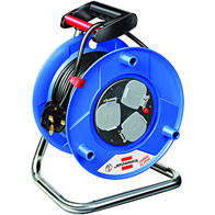
- Cable Reels & Wires
- Ceiling Fans & Accessories
- Circuit Breakers, Fuses & Load Centers
- Doorbells, Chimes & Accessories
- Electrical Boxes & Accessories
- Electrical Connectors, Tape & Terminals
- Extension Cords, Outlets & Accessories
- Interior Light Fixtures
- Light Bulbs & Accessories
- Light Fixture Parts
- Outdoor & Security Light Fixtures
- Portable Work Lights
- Electrical Switches & Sockets
- Home & Industrial
- Plumbing Supplies
- Building And Plumbing Supplies
Top Brands
Other Brands


- Electrical
-
Tools
- Power Tools
- Power Tools & Accessories
- Hand Tools
- Assembly Tools & Accessories
- Axes, Machetes & Shovels
- Chisels, Punches, & Nail Sets
- Concrete & Masonry Tools
- Drywall & Plastering Tools
- Electrical Tools
- Flooring Installation Tools
- Hammers & Screwdrivers
- Hand Saws & Accessories
- Workbenches, Sawhorses & Work Supports
- Spanners, Wrenches & Torque Wrenches
- Welding Machines
- Torque Wrenches & Multipliers
- Hand Tools & Accessories
- Tile Tools
- Tool Aprons, Trolley & Pouches
- Staple Guns & Brad Nailers
- Electrodes, Soldering & Welding Supplies
- Shaping & Marking Tools
- Pry & Wrecking Bars
- Nippers & Pliers
- Mechanic's Tools
- Material Handling
- Logging & Layout Tools
- Knives, Ratchet & Rivet Tools
- Sockets, Hex & Torx Keys
- Glazier & HVAC Tools
- Bricklaying Tools
Top Brand
Other Brands


-
Home & Outdoor
Top Brand

Other Brands


-
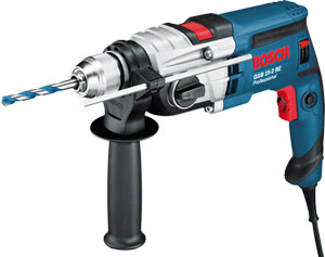
 Bosch Hot!
- Pros
- Skilled Professionals
- Architect
- Brick Mason & Brick Layer
- Building Surveyor
- Carpenter
- Civil Engineer
- Concrete Batcher & Block Moulders
- Concreter
- Construction & Building manager
- General Labourers
- Iron Bender (Steel fixer)
- Landscaper & Gardener
- Plasterer
- Plumber
- POP Installers
- Project Engineer
- Roofer
- Site Health and Safety Officer
- Site Engineer
- Stone Driller
- Structural Drafter
- Structural Engineer
- Tiller
- Welder
- Window and Glass Installer
- More Skilled Professionals
- Air Conditioning (AC) Repairer - Home & Industrial
- Air Conditioning (AC) Repairer - Car
- Electrician (House)
- Electrician (Car- Rewire)
- Home Decorator (Interior Designer)
- Mechanic Shop (General)
- Mechanic Shop (Japanese Car Specialist)
- Mechanic Shop (German Car Specialist)
- Mechanic Shop (American Car Specialist)
- Mechanic Shop (Tractors, Trucks and Heavy Duty Machines)
- Painter (House)
- Painter (Car)
- Panel Beater
- Repair Shop (Brush Cutter,Chainsaw & Lawn Mower)
PLUMBER

- Skilled Professionals
Compare (0)
You have no items to compare.
Welcome to Mamtus Nigeria


Details
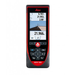
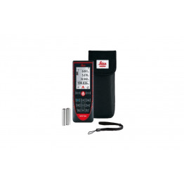
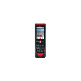
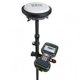
Product Description-
The Leica GS18 T is the fastest and easiest-to-use GNSS smart antenna and RTK rover because you save time by no longer needing to hold the pole vertical to level the bubble. This latest innovation, with industry-leading technology, combines GNSS and inertial measurement units (IMUs) to be the first true tilt compensation solution immune to magnetic disturbances and it is calibration-free. As you no longer need to watch and level the bubble, you can focus on your task at hand and save time over conventional surveying practices. Uninterrupted, accurate positioning when surrounded by or in close proximity to metallic objects - measure where others simply couldnt.
it directly out of the box without any calibration procedure.
You can forget the bubble when you use the Leica GS18 T. It is the original truly tilt compensating GNSS solution that is immune to magnetic disturbances and is calibration-free. The sensor fusion of GNSS and Inertial Measurement Unit (IMU) creates the original true tilt compensating GNSS smart antenna. For GS18, T means tilt.
As you no longer need to watch and level the bubble, you can focus on your task at hand and save time. The GS18 T works directly out of the box without any calibration procedure and like most of the Leica Geosystems GNSS Smart Antennas, you can use it as a rover and a base.
The Leica Captivate field software is the perfect companion for the GS18 T. With easy-to-use apps, all measured and design data can be viewed and used, providing you with a clear understanding of your data in 2D and 3D view. Captivate spans industries and applications with little more than a simple tap, regardless of whether you work with GNSS, total stations or both.
Please note that customer who purchased this also needs the base
Read more - Leica GS18 T data sheet
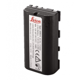
Additional Information
| Manufacturer | Leica Geosystems |
|---|---|
| Condition | New |
| Warranty | 1 year |
| Tax Class | None |
- Be the first to review this product
Write Your Own Review
Allowed only for defective and wrong items
Mamtus ensures you are satisfied with your purchase - product quality, secure payments and right of returns.
Contact: resolution@mamtus.com and get it resolved in good time.
Also Purchased


PREPAYMENT ONLY
No cancellation after confirmed payment.
FAST SHIPPING
Guaranteed nationwide 24 - 48hrs delivery anywhere in Nigeria.
₦
EASY RETURNS & MONEY BACK GUARANTEE
ONLINE SUPPORT 24/7
Call or WhatsApp 09091115007, 08168528651, 09091116661 & 09020444474
Related Products
Check items to add to the cart or select all
Delivery Methods
